


PRECINCT CENTER TOWNSHIP, Morgan County, Ohio
About
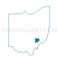
Outline

Summary
| Unique Area Identifier | 650699 |
| Name | PRECINCT CENTER TOWNSHIP |
| County | Morgan County |
| State | Ohio |
| Area (square miles) | 32.22 |
| Land Area (square miles) | 32.09 |
| Water Area (square miles) | 0.13 |
| % of Land Area | 99.59 |
| % of Water Area | 0.41 |
| Latitude of the Internal Point | 39.63025110 |
| Longtitude of the Internal Point | -81.65867920 |
Maps


Graphs
Select a template below for downloading or customizing gragh for PRECINCT CENTER TOWNSHIP, Morgan County, Ohio


Neighbors
Neighoring Voting District (by Name) Neighboring Voting District on the Map
- JACKSON Voting District, Noble County, OH
- PRECINCT BRISTOL/MANCHESTER, Morgan County, OH
- PRECINCT MEIGSVILLE TOWNSHIP, Morgan County, OH
- PRECINCT STOCKPORT/WINDSOR, Morgan County, OH
- SHARON Voting District, Noble County, OH
- WATERFORD A Voting District, Washington County, OH
- WATERFORD B Voting District, Washington County, OH
Top 10 Neighboring County Subdivision (by Population) Neighboring County Subdivision on the Map
- Waterford township, Washington County, OH (3,713)
- Windsor township, Morgan County, OH (2,089)
- Meigsville township, Morgan County, OH (895)
- Center township, Morgan County, OH (743)
- Jackson township, Noble County, OH (528)
- Sharon township, Noble County, OH (342)
- Bristol township, Morgan County, OH (191)
- Manchester township, Morgan County, OH (160)
Top 10 Neighboring Unified School District (by Population) Neighboring Unified School District on the Map
- Morgan Local School District, OH (14,178)
- Caldwell Exempted Village School District, OH (8,691)
- Fort Frye Local School District, OH (6,337)
- Wolf Creek Local School District, OH (3,473)
Top 10 Neighboring State Legislative District Lower Chamber (by Population) Neighboring State Legislative District Lower Chamber on the Map
Top 10 Neighboring State Legislative District Upper Chamber (by Population) Neighboring State Legislative District Upper Chamber on the Map
Top 10 Neighboring 111th Congressional District (by Population) Neighboring 111th Congressional District on the Map
Top 10 Neighboring Census Tract (by Population) Neighboring Census Tract on the Map
- Census Tract 213, Washington County, OH (5,111)
- Census Tract 216, Washington County, OH (3,707)
- Census Tract 9688, Morgan County, OH (3,296)
- Census Tract 9685, Noble County, OH (3,210)
Top 10 Neighboring 5-Digit ZIP Code Tabulation Area (by Population) Neighboring 5-Digit ZIP Code Tabulation Area on the Map
- 43724, OH (9,201)
- 43756, OH (5,320)
- 45786, OH (3,253)
- 45744, OH (2,728)
- 45715, OH (2,630)
- 45727, OH (516)